1936 Owens Birds Eye View of California 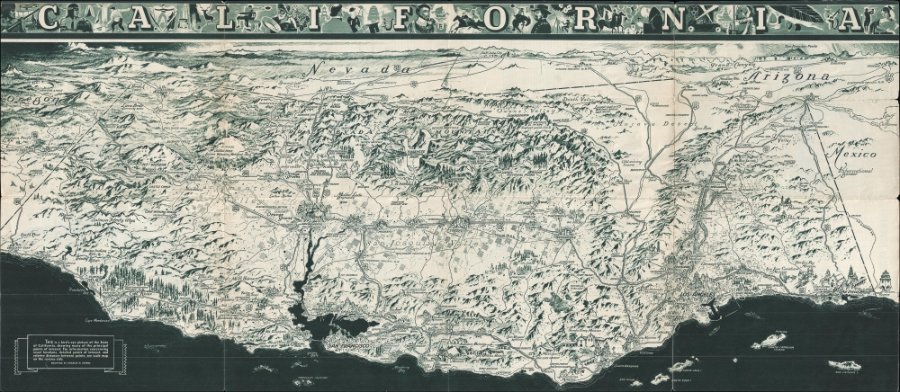 WE SELL ONLY ORIGINAL ANTIQUE MAPS - NOT REPRODUCTIONS Title: California. / California Official Tourist Picture Map. Description: This is a c. 1936 Charles Hamilton Owens birds eye view of California. The map depicts the state from Grants Pass, Oregon to Phoenix, Arizona and Tijuana, Mexico and from Salt Lake City, Utah to the Pacific Ocean. Wonderfully illustrated, cities and towns throughout California and the surrounding states are illustrated and labeled, including Sacramento, San Francisco, Los Angeles, San Diego, Las Vegas, Yuma, and Flagstaff. The transportation network is highlighted in detail, with major highways and railway lines illustrated and labeled. The Union Pacific, Southern Pacific, Western Pacific, and Santa Fe Railroads are among the labeled railroads. Several national parks, including Yosemite, Sequoia, and Redwood in California, Crater Lake in Oregon, and the Grand Canyon in Arizona are illustrated and labeled as well. Both Mount Whitney (the highest post in the United States at the time) and Death Valley (the lowest point in the United States) are labeled as well. Famous landmarks, such as the Golden Gate Bridge, the Oakland Bay Bridge, the Rose Bowl, and the California State Capital Building are all drawn in profile, adding another level of charm to this lovely piece. This map was drawn by Charles Hamilton Owens and published by the All-Year Club of Southern California in 1936. Size: Printed area measures 16.5625 inches high by 38 inches wide. Condition: Good. Wear along original fold lines. Verso repairs to fold separations. Old tape repairs on verso. Highway map of California on verso. Shipping: Shipping rates are not negotiable. Items are shipped within three business days of receiving payment. We are happy to consolidate shipping where possible. The following shipping options are available: 1. FedEx Overnight (45 USD). USA Only. Signature Required. Customs: International buyers are responsible for paying duty and taxes on delivery. DHL or FedEx will contact the buyer by telephone to arrange tax payment if it is levied. Duty varies by country and we cannot predict the amount you will be charged. Some countries are duty free, others are not. Typically, a customs duty and/or VAT tax will be assessed on all parcels to continental Europe. Sometimes duty or tax is due in China, but is seems very random. Hong Kong, Singapore, Korea, and Taiwan have never assessed duty on a map we shipped. Maps shipped to the UK should be duty free as educational materials, but from time to time duty of 5% is assessed incorrectly by the UK customs agents. Insurance: All shipments are insured privately against loss and damage. All of our shipments require a signature for insurance purposes. If you have any questions please feel free to email us through eBay. Other Services Conservation Framing: Geographicus recommends basic conservation framing services for any antique paper. We do not offer this service. |

1936 Owens Birds Eye View of California WE SELL ONLY ORIGINAL ANTIQUE MAPS - NOT REPRODUCTIONS Title: California. / California Official Tourist Picture Map. Description: This is a c. 1936 Charles Hamilton Owens birds eye view of California. The map depicts the state from Grants Pass, Oregon to Phoenix, Arizona and Tijuana, Mexico and from Salt Lake City, Utah to the Pacific Ocean. Wonderfully illustrated, cities and towns throughout California and the surrounding states are illustrated and labeled, including Sacramento, San Francisco, Los Angeles, San Diego, Las Vegas, Yuma, and Flagstaff. The transportation network is highlighted in detail, with major highways and railway lines illustrated and labeled. The Union Pacific, Southern Pacific, Western Pacific, and Santa Fe Railroads are among the labeled railroads. Several national parks, including Yosemite, Sequoia, and Redwood in California, Crater Lake in Oregon, and the Grand Canyon in Arizona are illustrated and labeled as well. Both Mount Whitney (the highest post in the United States at the time) and Death Valley (the lowest point in the United States) are labeled as well. Famous landmarks, such as the Golden Gate Bridge, the Oakland Bay Bridge, the Rose Bowl, and the California State Capital Building are all drawn in profile, adding another level of charm to this lovely piece. This map was drawn by Charles Hamilton Owens and published by the All-Year Club of Southern California in 1936. Size: Printed area measures 16.5625 inches high by 38 inches wide. Condition: Good. Wear along original fold lines. Verso repairs to fold separations. Old tape repairs on verso. Highway map of California on verso. Shipping: Shipping rates are not negotiable. Items are shipped within three business days of receiving payment. We are happy to consolidate shipping where possible. The following shipping options are available: 1. FedEx Overnight (45 USD). USA Only. Signature Required. Customs: International buyers are responsible for paying duty and taxes on delivery. DHL or FedEx will contact the buyer by telephone to arrange tax payment if it is levied. Duty varies by country and we cannot predict the amount you will be charged. Some countries are duty free, others are not. Typically, a customs duty and/or VAT tax will be assessed on all parcels to continental Europe. Sometimes duty or tax is due in China, but is seems very random. Hong Kong, Singapore, Korea, and Taiwan have never assessed duty on a map we shipped. Maps shipped to the UK should be duty free as educational materials, but from time to time duty of 5% is assessed incorrectly by the UK customs agents. Insurance: All shipments are insured privately against loss and damage. All of our shipments require a signature for insurance purposes. If you have any questions please feel free to email us through eBay. Other Services Conservation Framing: Geographicus recommends basic conservation framing services for any antique paper. We do not offer this service. |

